Flood Zone, Elevation, and Insurance: Why the House Next Door Can Carry a Different Risk
Flood Zone, Elevation, and Insurance: Why the House Next Door Can Carry a Different Risk
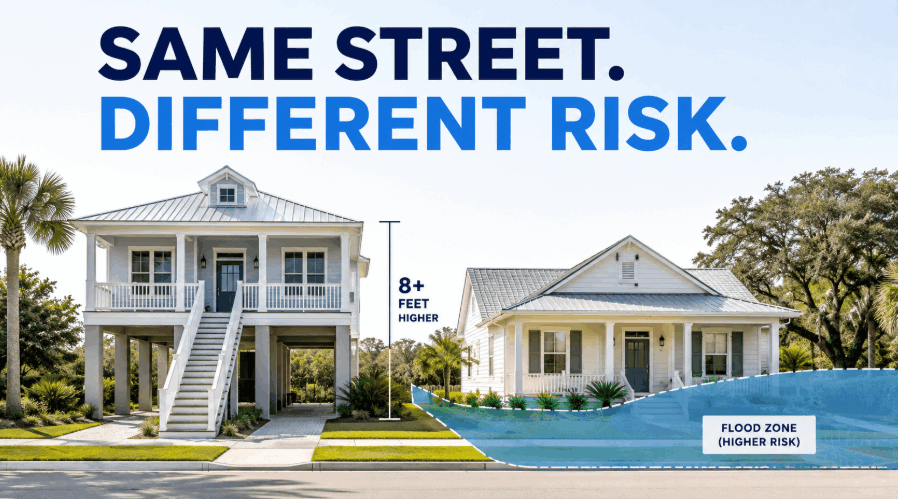
Two houses can sit beside each other, sell at a similar price, and look almost identical from the street. One may be relatively straightforward to insure. The other may require flood coverage, carry a much higher premium, or create questions that affect financing and resale.
That difference is not necessarily a mistake.
Flood risk is measured at the property and structure level. The flood-zone boundary, elevation of the home, foundation, construction details, distance from water, estimated rebuilding cost, coverage selected, and lender requirements can all change the answer.
The map can start the investigation. It cannot finish it.
A Flood Zone Is an Important Label, Not the Complete Risk Assessment
FEMA Flood Insurance Rate Maps divide land into different flood-hazard areas. Zones beginning with A or V are generally Special Flood Hazard Areas associated with the one-percent-annual-chance flood. When a structure in one of these areas secures a federally regulated or government-backed mortgage, flood insurance is normally required. Lenders may also require coverage outside those areas under their own underwriting standards.
That makes the flood-zone designation important, but buyers often give it more power than it actually has.
A flood-zone boundary can pass through a neighborhood, a parcel, or even part of a building. Federal lending guidance makes a distinction between the land and the structure: a lot extending into a high-risk area does not automatically create the federal insurance requirement if the building is outside it. However, if any portion of the building is inside the Special Flood Hazard Area, the requirement can apply.
That alone can explain why one neighbor receives a flood-insurance requirement while another does not.
It still does not tell you everything about their actual exposure or insurance cost.
Elevation Can Change the Meaning of the Zone
Base Flood Elevation, commonly called BFE, is the expected water-surface elevation during a flood with a one-percent chance of being equaled or exceeded in any given year. The useful comparison is between that elevation and the height of the building's lowest relevant floor.
Consider two houses in the same AE zone. One may have living space close to the Base Flood Elevation. The other may be raised several feet higher on piers, columns, an elevated crawlspace, or added fill.
They share the same general map designation, but the water would meet those structures very differently.
Flood zone tells you where the map places the property. Elevation tells you how the house meets the potential water.
Even small differences can matter. One lot may sit slightly higher. One builder may have elevated the finished floor more aggressively. One home may predate newer floodplain construction standards, while the neighboring home was built or substantially improved under stricter requirements.
A slab, crawlspace, garage enclosure, elevated foundation, and piling-supported home should not be treated as interchangeable simply because they share a street.
The Elevation Certificate Helps Explain the Building
An Elevation Certificate documents details such as the building's location, flood zone, lowest-floor elevation, and its relationship to the Base Flood Elevation. It is used for floodplain-management purposes and can help a property owner understand whether the building complies with local requirements.
Under FEMA's current National Flood Insurance Program pricing approach, an Elevation Certificate is not automatically required to purchase flood insurance. FEMA can estimate the first-floor height through its own tools. An owner may still submit a certificate to see whether the documented elevation produces a better insurance result. It can also support certain FEMA map-change requests when the mapped designation does not accurately reflect a structure located on naturally higher ground.
That means an Elevation Certificate should not be treated as a guaranteed premium reduction. It is better understood as evidence.
It can replace assumptions with actual measurements.
Before paying to have a new certificate prepared, buyers should check whether one already exists. The Town of Hilton Head Island maintains searchable elevation certificates submitted after 1983, while Beaufort County provides a certificate-request process and directs requests to the correct municipality based on the property's location and permitting history.
Current Flood-Insurance Pricing Looks Beyond the Zone
FEMA's Risk Rating 2.0 pricing approach uses more property-specific information than the older system. Relevant variables include flood frequency, storm surge, heavy rainfall, coastal erosion, distance to water, elevation, and the estimated cost to rebuild the structure.
Flood maps still matter for mandatory-purchase decisions and local floodplain regulation. They are no longer the only meaningful input in the National Flood Insurance Program premium calculation.
This is one of the biggest reasons buyers should stop asking only, "What flood zone is it in?"
Two homes can both be in Zone AE and still produce different quotes. Two homes can both be in Zone X and still carry different modeled risk. A larger, more expensive house may also cost more to protect because the potential rebuilding loss is higher.
Two roofs can be thirty feet apart and carry very different insurance math.
The House Itself Can Increase or Reduce the Exposure
Floodwater does not interact with every building in the same way.
The location of HVAC equipment, electrical components, and water heaters can affect how much damage a shallow flood creates. Elevating building equipment can reduce potential flood losses. Foundation type, properly designed flood openings, below-floor enclosures, and the location of finished living space can also change the building's exposure.
A raised home with utilities above the expected flood level is not the same physical risk as a neighboring slab home with mechanical equipment close to grade.
A garage or storage area under an elevated home also needs to be understood correctly. Buyers should not assume that every enclosed ground-level area is legally finished living space or that every improvement below the elevated floor is treated the same by floodplain regulations or insurance.
Those details can affect damage potential, rebuilding decisions, and buyer confidence later.
Flood Insurance Is Only One Part of the Coastal Insurance Package
Standard homeowners insurance generally does not cover flooding caused by rising water, storm surge, overflowing waterways, or accumulating surface water. Flood insurance is separate coverage.
Buyers may compare a National Flood Insurance Program policy with private flood-insurance options. The federal program and private market can offer different coverage structures, limits, deductibles, and additional protections. Private policies may offer options such as additional living expenses or loss-of-use coverage that are not structured the same way under a standard federal policy.
Flood coverage also does not settle the wind question.
Depending on the carrier and exact coastal location, wind and hail may be included in the primary homeowners policy or handled separately. Within South Carolina's designated coastal wind territory, an insurer may exclude wind coverage, leaving the owner to obtain a separate policy through another source, such as the South Carolina Wind and Hail Underwriting Association.
Roof condition, opening protection, roof-to-wall connections, and other storm-mitigation features can also influence available wind-related credits. South Carolina requires insurers to offer discounts for qualifying coastal mitigation measures, although the amount varies by company.
A buyer therefore needs more than one annual number. The useful comparison includes homeowners insurance, wind and hail coverage, flood insurance, deductibles, coverage limits, and any exclusions.
Zone X Does Not Mean the Property Cannot Flood
Zone X is commonly described as a moderate- or lower-risk designation, depending on whether the area is shaded. It usually means the federal flood-insurance purchase requirement does not apply automatically.
It does not mean the property has no flood exposure.
A meaningful share of flood claims occurs outside current high-risk flood areas. Heavy rainfall, drainage limitations, changing development patterns, and localized surface-water problems do not always follow a clean map boundary.
A Zone X home with poor drainage, low mechanical equipment, and a history of standing water may deserve more investigation than a well-elevated home inside a mapped high-risk zone.
The zone helps classify the hazard. It does not promise how the property will perform in every storm.
Insurance Quotes Need to Happen Before the Buyer Is Committed
A seller's current premium can provide context, but it should not be treated as the buyer's future cost. Coverage limits, deductibles, insurer eligibility, policy discounts, occupancy, rebuilding estimates, and the buyer's chosen coverage can all change the quote.
The safer approach is to obtain insurance pricing for the exact address while the buyer still has time to evaluate the purchase.
That pricing should cover the full package rather than flood alone. A house with a manageable flood premium may still have an expensive homeowners or wind policy. Another home may require flood coverage but carry a more predictable total cost because it is newer, elevated, and easier to insure.
A lower purchase price is not a bargain when the insurance package erases the savings every year.
Buyers comparing HILTON HEAD HOMES or BLUFFTON HOMES should also avoid making neighborhood-wide assumptions. One owner's premium is not a reliable estimate for the next house, even when the homes share a community, builder, or floor plan.
What Sellers Can Do Before the Insurance Question Slows the Sale
Insurance uncertainty can make an otherwise interested buyer hesitate. A seller cannot promise what another person's policy will cost, but the property can be made easier to evaluate.
An existing Elevation Certificate, accurate roof age, wind-mitigation documentation, permit records, and clear information about past flood-related repairs can help the buyer and insurance agent understand the home faster. Sellers should also be prepared for the buyer to obtain independent quotes rather than relying on the seller's current declarations page.
The goal is not to convince the buyer that there is no risk.
The goal is to make the risk measurable enough that the buyer can decide whether the property still makes sense.
How to Compare Two Lowcountry Houses Properly
Start with the FEMA map, but do not stop at the zone letters.
Confirm whether the structure itself crosses the mapped boundary. Review the Base Flood Elevation and any available Elevation Certificate. Look at the finished-floor height, foundation, enclosures, mechanical equipment, roof, mitigation features, and drainage around the property.
Then obtain quotes for the exact house using the buyer's expected occupancy and coverage needs. Confirm the lender's insurance requirements before the financing contingency becomes difficult to use.
The strongest comparison is not AE versus X or flood insurance versus no flood insurance. It is total ownership cost, physical exposure, available coverage, and the confidence that another buyer will be able to understand the property when it is eventually resold.
The house next door may look almost the same. On paper, underneath the home, and inside the insurance model, it may be a completely different purchase.
Final Takeaway
Flood risk in the Lowcountry should not be reduced to one letter on a listing sheet.
The map matters. Elevation matters. Construction matters. Insurance underwriting matters. The lender matters. The buyer's coverage choices matter.
A high-risk flood-zone designation is not an automatic reason to reject a house. A lower-risk designation is not permission to ignore the issue.
The map triggers the question. The exact property supplies the answer.
Message me if you are comparing Hilton Head or Bluffton homes and want help identifying which property-specific questions should be answered before you commit.
 Frequently Asked Questions
Can Two Neighboring Houses Be in Different Flood Zones?
Yes. Flood-zone boundaries can cross streets, lots, and individual structures. The location of the building—not simply the neighborhood name or mailing address—helps determine the federal flood-insurance requirement.
Does Zone X Mean Flood Insurance Is Unnecessary?
Zone X generally represents moderate or lower mapped risk and may not trigger the federal purchase requirement. Flooding can still occur, and lenders may impose their own coverage requirements. Buyers should evaluate the property and available quotes rather than relying on the zone alone.
Will an Elevation Certificate Lower the Premium?
Not automatically. An Elevation Certificate can document a more favorable first-floor height and may produce a lower quote, but the result depends on the complete rating information. It is also useful for confirming floodplain compliance and supporting certain FEMA map-change requests.
Is Flood Damage Covered by Homeowners Insurance?
Standard homeowners policies generally exclude damage caused by rising floodwater and storm surge. Separate flood coverage is usually needed.
Should Buyers Compare Federal and Private Flood Insurance?
Yes. Coverage limits, deductibles, exclusions, and additional protections may differ. Buyers should review both price and coverage rather than choosing a policy solely because the premium is lower.
Categories
- All Blogs (108)
- Hilton Head Condo Buyer Strategy (7)
- Beach Access & Coastal Ownership (1)
- Bluffton & Lowcountry Living (2)
- Bluffton Buyer / Seller / Comparison Topics (2)
- Bluffton Communities and Relocation (4)
- Bluffton Real Estate (8)
- Bluffton Real Estate / Relocation Guide (2)
- Buyer Advice (1)
- Buyer Guides (1)
- Costs, Fees, Insurance, Financing, and Due Diligence (1)
- Golf / Private Club / Gated Community Living (1)
- Golf / Private Club Communities (1)
- Hilton Head & Bluffton Buyer Strategy (1)
- Hilton Head Area Comparisons (1)
- Hilton Head Communities (4)
- Hilton Head Communities & Area Guides (11)
- Hilton Head Condo Buyer Guide (9)
- Hilton Head Condo Market Updates (1)
- Hilton Head Condo Seller Strategy (1)
- Hilton Head Condos & Villas (14)
- Hilton Head Homes (1)
- Hilton Head Homes + Island Living (2)
- Hilton Head Homes and Island Living (1)
- Hilton Head Real Estate (1)
- Hilton Head Seller Strategy (8)
- Hilton Head Short-Term Rental + Investment Guide (1)
- Hilton Head vs Bluffton (1)
- Hilton Head vs Bluffton / Relocation (3)
- Lowcountry Homeownership (1)
- Market Reports & Trends (4)
- Relocation and Retirement (1)
- Retirement & Relocation (1)
- Retirement and 55+ Communities (1)
- Retirement and Relocation (2)
- Retirement, 55+ & Private Club Living (3)
- Seller Strategy and Valuation (1)
- Short-Term Rentals & Investment (3)
Recent Posts